


Oregon Series Owner’s Manual 17
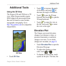
The Oregon 450t and 550t have a 3D
view. Other Oregon models require
DEM (digital elevation model) data
that can be found in some Garmin
topographic cartography. Go to
http://buy.garmin.com for compatible
map products.
• Touch 3D View.
• Touch
to increase the angle
of elevation, and touch to
decrease the angle of elevation.
• Touch to pan the 3D map
forward, and touch to pan the
3D map backward.
• Touch to rotate the view to
the left, and touch to rotate
the view to the right.
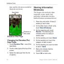
The Oregon can record elevation
changes over distance or time, or
pressure (barometric or ambient)
changes over time. To set which
changes are recorded, see page 32.
• Touch Elevation Plot to open the
Elevation Plot page.
• To adjust the distance or time
scale, touch or .
• To display elevation data, touch
a point on the plot. The time, the
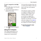
Additional Tools