


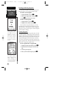
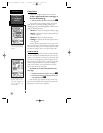

Route Navigation
The last form of navigating to a destination with the
GPS 126/128 is to create a user-defined route. The
GPS126/128 lets you create and store up to 20 routes of
30 waypoints each. The route navigation feature lets
you plan and navigate a course from one place to
another using a set of pre-defined waypoints. Routes are
often used when it’s not practical, safe, or possible to
navigate a direct course to a particular destination (e.g.,
through a body of water).
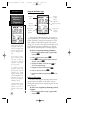
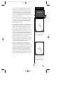
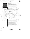
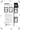
Routes are broken down and navigated in smaller
segments called “legs”. The waypoint you are going to
in a leg is called the “active to” waypoint and the way-
point immediately behind you is called the “active from”
waypoint. The line between the “active to” and the
“active from” waypoint is called the “active leg.”
Whenever you activate a route, the GPS 126/128
will automatically select the route leg closest to your
position as the active leg. As you pass each waypoint in
the route, the receiver will automatically sequence and
select the next waypoint as the “active to” waypoint.
Routes
REFERENCE
28
Waypoint 2
(“active to” waypoint)
Waypoint 1
(“active from” waypoint)
“Active Leg”
126/128 Manual (new) 6/15/98 9:51 AM Page 28