


Appendix
54 Montana 600 Series Owner’s Manual
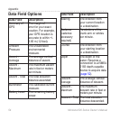
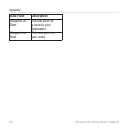
Data Field Options
Data Field Description
Accuracy of
GPS
The margin of
error for your exact
location For example,
your GPS location is
accurate to within +/-
365 m (12 feet)
Ambient
Pressure
The uncalibrated
environmental
pressure
Ascent -
Average
The average vertical
distance of ascent
Ascent -
Maximum
The maximum ascent
rate in feet or meters
per minute
Ascent - Total The total elevation
distance ascended
Barometer The calibrated current
pressure
Battery Level The remaining battery
power
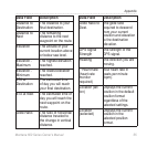
Data Field Description
Bearing The direction from
your current location
to a destination
Cadence
(cadence
accessory
required)
Revolutions of the
crank arm or strides
per minute
Course The direction from
your starting location
to a destination
Depth The depth of the
water Requires a
connection to a NMEA
0183 depth-capable
device to acquire data
(page 52)
Descent -
Average
The average vertical
distance of descent
Descent -
Maximum
The maximum
descent rate in feet or
meters per minute
Descent - Total The total elevation
distance descended