


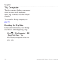

Navigation
Montana 600 Series Owner’s Manual 21
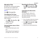
Elevation Plot
By default, the elevation plot displays
the elevation for an elapsed time.
To customize the elevation plot, see
page 40.
Select > .
Changing the Plot Type
You can change the elevation plot to
display pressure and elevation over
time or distance.
1. Select > > >
.
2. Select an option.
Viewing Details about a Point
on the Plot
Select an individual point on the
plot.
Details about the point appear in
the upper-left corner of the plot.
Resetting the Elevation Plot
Select > >
>
>.
Calibrating the Barometric
Altimeter
You can manually calibrate the
barometric altimeter if you know
the correct elevation or the correct
barometric pressure.
1. Go to a location where the elevation
or barometric pressure is known.
2. Select > > >
.
3. Follow the on-screen instructions.