


7. CUSTOMIZING YOUR UNIT
7-20
*
2
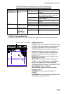
NATURAL FEATURES: Any topographic features formed by the action of natural
process.
*
3
CULTURAL FEATURES: Any man made topographic feature; built-up areas, roads.
*
4
LANDMARK: Any prominent objects such as monument, building, silo, tower etc. on land
which can be used in determining a location or a direction.)
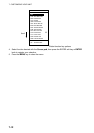
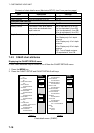
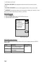
DEPTH INFO soft key
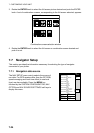
1. Press the MENU key.
2. Press the CHART SETUP and CHART DETAILS soft keys.
3. Press the DEPTH INFO soft key.
DEPTH AREA
PLOTTER
DEPTH AREAS LIMIT
00002-00009 m
DEPTH LINES & SOUNDINGS
PLOTTER/OVERLAY
DEPTH LINES & SOUNDINGS LIMIT
00000-000305 m
ROCKS DEPTH LIMIT
00000 - 00009 m
DEPTH
INFO
EDIT
RETURN
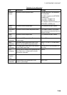
DEPTH INFO menu
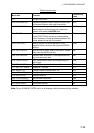
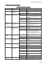
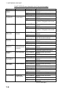
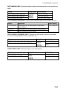
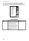
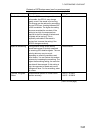
DEPTH INFO menu description
DEPTH AREAS: Choose the display where to fill in color the depths selected at DEPTH
AREAS LIMIT.
Setting Description Default Setting
PLOT/OVERLAY
Turns on depth area display on
plotter and overlay displays.
PLOTTER
Turns on depth area display on
plotter display.
OFF
Turns off depth area display.
PLOTTER