


Notes on the Route Guidance
38
NAX980HD
English
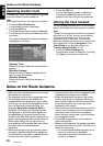
Selecting another route
Changes the current route to another suggested
route with different priority conditions.
Note:
When waypoints are set, this operation is disabled.
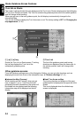
1. Touch the [More Routes] key.
A confirmation screen is displayed.
2. Touch the [OK] key.
The More Routes menu screen is displayed.
3. Touch the desired priority condition you wish
to confirm.
The route of the specified priority condition is
highlighted on the map.
[Shortest Time]
Shows the route of which the required time is
shortest.
[Minimize Freeway]
Shows the route of which freeways are not
used as much as possible.
[Shortest Distance]
Shows the route of which the distance is
shortest.
4. Touch the [OK] key.
The Set Route menu screen is displayed.
Touching the [Start] key starts the route
guidance with the route you have selected.
Storing the track traveled
You can register the track which is the traveled
path on the vehicle up to the current car position.
Note:
The track is automatically recorded from the place of
departure up to 100 km, and the current tracking
from the current location up to 20 km can be
registered for up to five tracks. You can select
whether to display track traveled or not, and you can
also register/edit it from the [Navigation] or the
[Stored Data] of the navigation settings. ➜
“Tracking Display Settings” (P. 42).
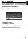
1. Touch the [Store Tracking] key.
A confirmation screen is displayed. Touching
the [Yes] key stores the current track.
Notes on the Route Guidance
• When you enter the destination, be sure to stop
the vehicle in a safe place.
• The displayed route is only a suggested route.
• The guidance routes on the Roads with
Incomplete Data are displayed in green. When
the Turn by Turn screen is displayed while you
are on a Road with Incomplete Data, the
message “Road with Incomplete Data” is
displayed. The Roads with Incomplete Data
are the roads of which the traffic regulations
and geometries of the roads have not been
verified by the Map D/B supplier. Because the
system cannot generate the route guidance for
these roads, neither turn by turn arrow nor
voice guidance will be issued. Be sure to follow
the actual traffic circumstances and
regulations.
• Roads can change every day, and may have
changed in geometries and traffic regulations
from the date the map data is created. Be sure
to follow the actual traffic regulations.
• It may take a little time until the suggested route
is displayed according to the situation.
• When the destination is entered, the current
location map screen is displayed. When you
set a remote position from the vehicle position
as the starting point, the route may not be
displayed on the screen.
• Roads where the vehicle cannot pass, such as
roads in housing areas site or in installations,
and roads under construction, and places
where vehicles cannot pass, may be included
in the suggested route.
• The passed waypoints are not included for
route recalculation.
• When you set waypoints, the system calculates
the routes between every point. Therefore, the
following notes apply:
• If a route between certain waypoints is not
found, no route may be displayed.
• The route may not be connected in the
vicinity of a waypoint.