


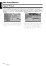

Map Screen Features
18
NAX980HD
English
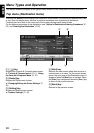
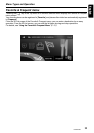
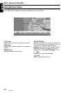
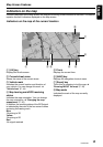
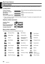
Map symbols
This navigation system indicates information such as roads and facilities using symbols and colors.
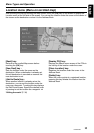
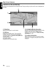
Transportation
*1:These roads have not been verified by the Map D/B supplier. The system cannot generate the route
guidance for these roads.
Highway markers (example)
Map symbols (examples)
The following map symbols are displayed on the map.
:
:
:
:
:
(Blue with light blue border/Red with light red border)
(Red)
(Brown with dark brown border)
(Gray)
Primary Freeways
Secondary Freeways
Main Roads
Minor Roads
Road with Incomplete Data
*
1
(Gray)
Interstate Route :
:
:
US Route
State or Provincial Route
:Trans-Canada Highway
:Canadian Autoroute
Municipal Office
Military Base
Airport
Main Station
Station
Ferry Terminal
Service Area
Parking Lot
Parking Garage
Rental Car Company
GAS Station
Historical Site
Science Museum·
Art Museum
Tourist Information
Center
Park & Ride
Recreation Ground
Sports Complex
Library
University or College
Bank
Restaurant
Shopping Center
Court House
Police Station
Supermarket
Golf Course
Marina
Marina
Other Facilities
Clarion
Service Station