


User’s Manual NAVIGON 2100 | 2110 max
Navigation - 39 -
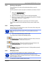
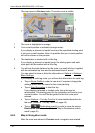
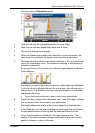
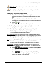
The map opens in Navigation mode.
1 Here you can see the signposting which you must follow.
2 Here you can see any speed limits which are in force.
3 The route is highlighted in orange.
4 When two manoeuvres need to be executed in quick succession, the
small arrow box indicates the second manoeuvre to be executed.
5 The large arrow box shows a schematic depiction of the next junction at
which you must make a turn. The distance remaining to this junction is
indicated underneath.
As you get closer to the junction you will see a spot diagram in addition
to the distance:
The nearer you get to the junction, the more yellow spots are displayed.
If you don't have to change direction for a long time, you will see only a
straight arrow. The distance you must continue straight on is indicated
underneath the arrow.
► Tap on the large arrow box to hear current route instructions.
6 Ahead of many junctions the information from 7 and 8 is hidden. Instead
you a
re shown which lanes lead to your destination.
7 The height above sea level and the current speed are indicated here.
8 In the Total box you can see the distance remaining to the destination,
the estimated duration of the trip and the estimated time of arrival.
9 Your current position is indicated on the map (orange arrow). The
section of the map displayed changes continually so that your current
position is always in view on the map.