


11
www.magellangps.com
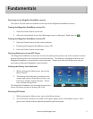
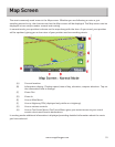
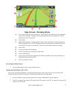
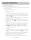
(A) Turn instructions for next maneuver. Tap to display the maneuver list (available
only when routing). Distance and road name for the next maneuver. Tap to
repeat last voice instruction.
(B) Speed limit
(C) Information display. Displays speed, time of day, elevation, compass direction.
While routing it also can also display distance to destination, estimated time of
arrival (ETA), and time remaining. Tap on the information field to change.
(D) Zoom Out
(E) Current position and heading.
(F) Zoom in controls to change the map scale.
(G) Access Main Menu.
(H) Access the list of nearest Highway Exit POIs (available only when driving on a
highway/freeway/interstate).
(I) Access volume controls.
Accessing the Map Screen
1. On the Main Menu screen, tap the Back arrow.
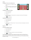
Setting the Map Modes (2D or 3D)
The map is normally displayed in 3D mode (perspective view) but you can set the map to 2D
mode (top down view) if so desired. Choose the mode that suits you best.
1. From the Map screen, tap anywhere on the map. Additional controls appear.
2. Tap 2D to switch the map to 2D mode from 3D mode, or tap 3D to switch the map to 3D
mode from 2D mode.