


Magellan GPS Tracker 35
Projecting a Waypoint
This function allows you to create a waypoint at a certain distance and
direction from an existing waypoint or from your current position.
From any NAV screen, press MENU, highlight WAYPOINTS and press
ENTER. Highlight the waypoint you wish to project and press
ENTER. Press MENU, highlight PROJECTION and press ENTER.
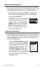
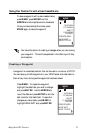
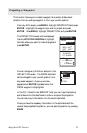
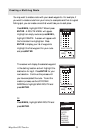
The PROJECTION screen will be displayed.
Use the UP/DOWN ARROWs to highlight
the field where you want to make changes and
press ENTER.
You can change any of the four sections in the
PROJECTION screen. The FROM data field
can be changed to your current position or to
any saved waypoint. A pop-up window
appears when ENTER is pressed when the
FROM waypoint is highlighted.
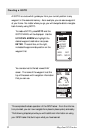
In the G.C. (Great Circle) BRG/DST field, you can input the bearing
and distance into the data fields in order to compute the projection.
You can also input information into the coordinate fields.
Once you have the necessary information in the data fields and the
receiver has projected the position, you can save the position by pressing
MARK.
PROJECTION
FROM
WPT003
G.C. BRG/DST
BRG 000
˚
DST 000
M
I
LAT/LON
34˚08.56N
117˚50.60W
UTM
23
11 4 760W
74
37
479N
M
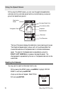
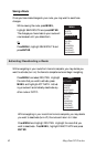
WAYPOINTS
POS
CAMP
HOTSPT
FISH