


Magellan GPS Tracker 23
Selecting PAN-N-SCAN
By using PAN-N-SCAN, you can look ahead or review where you have
travelled according to waypoints, routes and track history. PAN-N-SCAN
allows you to view the area from .20 miles to 320 miles, depending on your
selection.
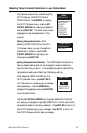
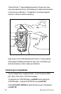
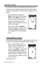
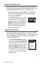
While viewing the PLOT screen, press
MENU, highlight PAN-N-SCAN and press
ENTER. Use the ARROWs to move the
cursor. When the cursor is placed over the
waypoint icon, the header will read TO:
(waypoint name) and the BRG and DST will
show that of the waypoint.
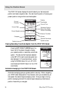
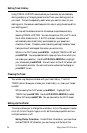
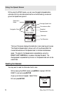
While in PAN-N-SCAN, press MENU to
reveal the menu screen. If the cursor is over a
waypoint when MENU is pressed, the menu
will be displayed with WPT INFO added to
the list.
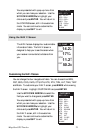
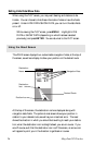
Displaying Waypoint Information
As you navigate using PAN-N-SCAN, it might be useful to have the name of
the waypoint you are heading towards appear at the top of the screen.
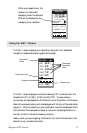
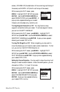
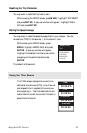
While in the PAN-N-SCAN screen, the
waypoint name can be inserted at the top of
the screen. Place the crosshair over the
waypoint and press MENU. Highlight WPT
INFO and press ENTER. The waypoint
information screen will appear in place of the
PAN-N-SCAN screen. Press QUIT to return
to PAN-N-SCAN with the waypoint name at
the top of the screen.
Default setting is ON.
WPT001
BRG
000
m
DST
0.0
n
m
2.0
m
I
N
°
PAN-N-SCAN
BRG
000
m
DST
0.0
n
m
2.0
m
I
N
°