


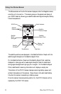
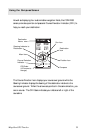
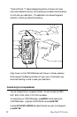

22 Magellan GPS Tracker
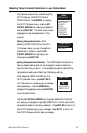
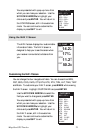
Using th
e Plot
Screen
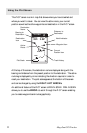
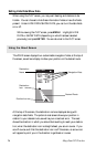
The PLOT screen is a mini map that shows where you have travelled and
where you want to travel. You can view the active route, your current
position as well as the other waypoints and destination in the PLOT screen.
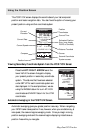
At the top of the screen, the destination name is displayed along with the
bearing and distance from the present position to the destination. The active
route leg is displayed by a line indicating the direction required in order to
reach your destination. The plot scale appears at the bottom of the screen
and can be changed by using the RIGHT/LEFT ARROWs.
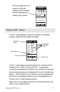
An additional feature of the PLOT screen is PAN-N-SCAN. PAN-N-SCAN
allows you to use the ARROWs to scroll through the PLOT screen enabling
you to create waypoints and routes graphically.
Distance to
Destination
North Indicator
Waypoint Icon
Current
Position Icon
Track History
Destination
Name
Bearing to
Destination
Destination
Icon
Plot Scale
TO: FISH
BRG
351
m
DST
3.52
m
I
2.0
m
I
N
HOME
FISH 2
FISH
DOCK
BUOY
°
Active
Route