


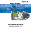
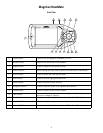
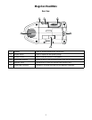
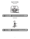
Information
2
using signal corrections from a network of ground stations and fixed-position satellites known as WAAS (Wide-Area
Augmentation System). Throughout Europe a similar system, EGNOS (European Geostationary Navigation Overlay System),
provides the same accuracy. In Asia, satellite navigation-signal correction is provided by MSAS (Multi-functional Transport
Satellite-Based Augmentation System). Other ways to increase the accuracy of satellite navigation include the use of DGPS
(Differential Global-Positioning System); ground relay stations, set at known positions, transmit corrected satellite-navigation
signals. Various methods and applications of DGPS can increase satellite-navigation accuracy from a few meters to within a
few millimeters. Using DGPS requires a differential-beacon receiver and antennae in addition to a satellite-navigation
device. Accuracy can also be increased using an RTK (Real-Time Kinematic) satellite-navigation system. This is a receiver
capable of transmitting a phase-corrected signal from a known position to one or more rover receivers.
A number of positioning errors can occur, limiting accuracy to within 15 to 25 meters. These errors are monitored and
compensated for in a number of ways:
Orbiting errors -- Occasionally, a satellite's reported position does not match its actual trajectory. In the U.S., the
Department of Defense continuously monitors each satellite, making orbital corrections with on-board booster rockets.
Poor geometry -- If all of the satellites within line of sight of a receiver are clustered closely together, or lined up relative to
the position of the receiver, the geometric calculations necessary for triangulating a position become difficult and less
reliable. The use of differential-correction signals from satellite-based augmentation systems or DGPS can compensate for
both orbital errors and poor geometry.
Multipath signals -- Signals may be reflected off tall buildings or other obstructions before reaching the receiver, increasing
the distance a signal travels and reducing accuracy.
Thales Navigation receivers make a number of complex mathematical calculations to effectively compensate for other
potential errors in positioning:
Atmospheric delay -- Satellite-navigation signals slow as they pass through Earth's atmosphere. Thales Navigation receivers
calculate the average delay in nanoseconds to compensate.
Clock errors -- The clock built into a receiver is not as accurate as the atomic clock on a navigation satellite, which is
accurate to one second every million years. Each Thales Navigation receiver compensates for time differentials by comparing
the time signals of several satellites and adjusting its calculations and its clock to match.
A Word on the Safe Usage of GPS Maps
Just like paper maps, maps on GPS devices vary greatly in terms of information included and visual presentation. Whether
topographical maps, roadmaps or marine charts, each map and the data it presents is designed for a specific purpose. For
example, marine charts will often present only a minimal representation of roadways and are not a substitute for street maps.
Topographic maps usually provide minimal detail about bodies of water and do not contain marine navigational markers.
Maps also vary widely in scale: the smaller the scale, the more detailed the map. Therefore, when using GPS maps (just as
with paper maps) it is important to consider what type of map you are using in your explorations and to use common sense.
From Source to Destination
Thales Navigation, maker of Magellan GPS products, is not a cartography company. We do not create the maps that are used
on our GPS devices. We seek to acquire map data from the best public and private sources available at the time of
publication. Thales Navigation licenses* topographical maps, roadmaps, marine charts and points of interest (POI) data
from commercial and governmental cartographic sources that provide raw map data. Thales Navigation processes and
compresses the raw data into a format that makes it presentable and manageable to work on our GPS devices. And to ensure
that our map data is as robust as possible, data from multiple sources are often combined to provide a better user experience
for our customers. This processing does not alter the landforms, coordinates or other spatial data that comes in the raw data.
The accuracy of the maps is fundamentally dependent on the source data used to create them. Map data changes frequently
due to both natural and man-made causes. As a result, governmental and commercial cartography companies must