


Traveling
24
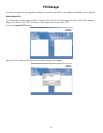
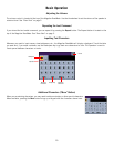
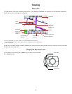
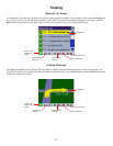
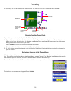
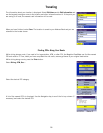
Map Screen
The Map screen is the most commonly used screen in the Magellan RoadMate and provides you with detailed information
about where you are and where you are going.
† By touching the POI icon on the screen, you can get information and route to it.
†† Blue = WASS Signal, Green = Strong Signal, Yellow = Average Signal, Red = Weak Signal,
Black = No Signal
As you travel, the Map screen constantly updates your location and provides you with not only a map but a visual indication
of where you are on the map.
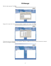
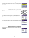
Changing the Map Zoom Levels
You can zoom in by pressing the + (plus) button or zoom out by pressing
the - (minus) button.
Estimated Time to
Destination
Direction of Travel
and GPS Signal
Strength ††
Position Cursor
(points in the
direction you are
traveling)
Distance to Destination
Direction of Destination
Distance to Next
Maneuver
Planned Route (pink)
Next Maneuver
Current Road
Next Road
POI Icon †
Zoom In Button
Zoom Out Button