


Profiles 31
Profiles
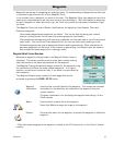
The Magellan Triton gives you the means to set up three profiles; Hiking, Marine and Geocaching.
Each profile contains custom settings that you can select. You can customize the profiles to fit your
particular needs. You will notice that the background colors for the screens change depending upon
the profile selected.
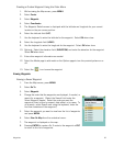
Activating a Profile
1. From the Map screen press MENU.
2. Select View.
3. Select Profiles.
4. Select the profile you want to use from the Active Profile drop-
down menu.
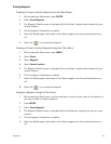
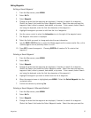
Editing a Profile
1. From the Map screen press MENU.
2. Select View.
3. Select Profiles.
4. Select the profile you want to edit from the EDIT PROFILE buttons.
5. Use the PAGE / GO TO button to select the page to edit.
6. When all of the options have been set, use the ESC button to exit.
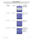
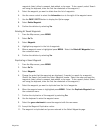
Information Page (assigns which navigation screens are displayed)
Use the cursor control to highlight the navigation screens and select between On or Off.
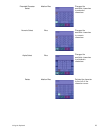
Display Page
Map Page
DISTANCE
Miles/Feet, Miles/
Yards, NtMi/Meters,
NtMi/Feet
Sets the unit of measure for distance
measurements.
SPEED
Kph, Mph, Kts Sets the unit of measure for speed
measurements.
ELEVATION
Meters, Feet Sets the unit of measure for elevation
measurements.
BAROMETER
UNITS
kPa, Millibar, inHg,
mmHg
(Magellan Triton 2000 only) Sets the unit
of measure for barometric measurements.
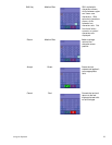
ORIENTATION
North Up, Course Up,
Track Up
Sets top of the Map screen display to
indicate North, your heading (course) or
your track.