


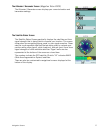
Navigation Screens 13
4. Select the Profile to edit.
5. On the Info Page use the cursor control to select the Navigation screen you want to turn on
or off.
6. Press ENTER.
7. Highlight On or Off from the drop down menu and press ENTER.
8. Press ESC until you return to the Navigation screen.
Customizing Fields
Six of the Navigation screens can have the data fields customized to display data that is the most
useful to you. You can select from latitude, longitude, heading, bearing, distance to next waypoint,
distance to the end of the route, time to next waypoint, time to the end of the route, current time,
date, destination, XTE, elevation, current speed, average speed, maximum speed, distance made
good (DMG), estimated time of arrival (ETA), accuracy, velocity made good (VMG), odometer, and
current trip odometer.
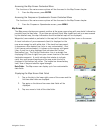
Customizing the Data Fields for the Map Screen
1. While viewing the Map screen, select ENTER.
2. Select Customize Fields.
3. Use the cursor control to select the desired field.
4. Select ENTER.
5. Select the data type desired from the list shown and press ENTER.
6. Press ESC when done.
(Note: you can set the number of data fields displayed on the map screen to none, 2 or 4 by
pressing ENTER, selecting Map Options and choose the desired number of data fields under
MAP DATA FIELDS.)
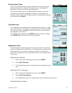
Customizing the Data Field for the Large Data, Compass or Satellite Status Screen
1. While viewing a screen that has customizable data fields, press ENTER. The first data field
will be displayed in pale orange.
2. Select the field you want to change and with it highlighted, press ENTER.
3. Select the data type desired from the list shown and press ENTER.
4. The Triton will return to the original screen with the data field customized to display the
information selected.
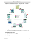
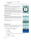
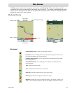
Contextual Menus
The Map screen, the Compass screen and the Speedometer screen, have contextual menus associated
with them. The Map screen contextual menu provides most of the operations that would be needed
during normal use (save a waypoint, go to a waypoint, local information, backtrack and more). The
Compass and Speedometer contextual menus provide access to operations associated with the
screen.