


Map Screen 20
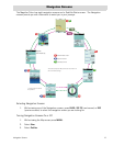
Map Screen
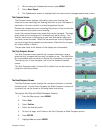
The Map screen is the most commonly used screen in the Magellan Triton and it has a special
contextual menu that can access the commonly used functions. This makes understanding the Map
screen and all of the functions that can be performed directly from this screen an important part of
getting the most out of your receiver.
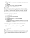
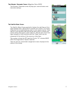
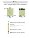
Map Screen Overview
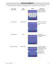
Map Legend
Present Position Cursor (Points in the direction of travel.)
Pan Cursor (Cursor indicating point on the map while panning around the screen.
Red dot points towards your current position.)
Computed Route Indicator (Line of sight pointer to next destination from where
the route originated.)
Current Route Indicator (Line displaying line of sight to the destination from
current location.)
Track (Displays previous travel.)
Trail (Track that has been saved in the receiver.)
Start Flag (Indicates the starting point of the active route.)
End Flag (Indicates the ending point of the active route.)
Waypoint (Indicates the position of waypoints saved in the receiver. Default icon
shown. User can assign a different icon from the Waypoint Information screen.)
GPS Signal Strength
Time of Day
Battery Level
North Indicator
Map Scale
Data Fields
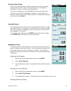
Pan Mode