


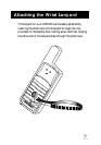


38
Glossary
Active Leg The segment of a route currently being used
to compute navigational information.
Bearing The compass direction from your position
to a destination, measured to the nearest
degree.
Coordinates A unique numeric or alphanumeric
description of position.
Datum Refers to the theoretical mathematical
model of the earth’s sea level surface. Map
makers may use a different model from
which to chart their maps, so position
coordinates will differ from one datum to
another. The datum for the map you are
using can be found in the legend of the
map. If you are unsure as which datum to
use, use WGS84.
Elevation Distance above mean sea level.
GOTO A single leg route with the present position
being the start of the route and a defined
landmark as the destination. (If the unit has
been moved while turned off and has not
yet acquired a new position fix, the start of
the GOTO will be the position fix last
recorded.)
Heading The compass direction in which the
Magellan GPS 300 is moving.