


74
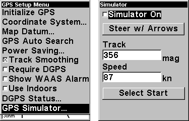
GPS Simulator
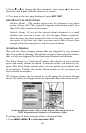
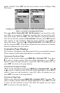
The GPS simulator lets you use the unit as if you were outdoors navi-
gating somewhere. You can set the starting location in lati-
tude/longitude (Starting Position) or from a stored waypoint location
(Select Starting Waypoint). You can steer your position on the map by
using the arrow keys (Steer With Arrows) or by setting the track and
speed in the boxes provided on simulator screen.
To get to the GPS Simulator:
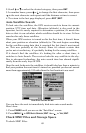
1. Press
MENU|MENU|↓ to GPS SETUP|ENT.
2. Press ↓ to
GPS SIMULATOR|ENT.
Make the desired settings, then turn the simulator on by highlighting
the
SIMULATOR ON box and pressing the ENT key. Press EXIT to erase this
menu. A message appears periodically, warning you that the simulator is
on. Repeat the above steps or turn the unit off to turn the simulator off.
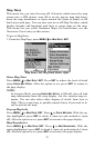
GPS Setup Menu, left, GPS Simulator Menu, right.
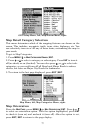
Map Auto Zoom
This receiver has an auto zoom feature that eliminates much of the but-
ton pushing that other brands of GPS receivers force you to make. It
works in conjunction with the navigation features.
First, start navigation to a waypoint. (See the waypoint section for
more information on navigating to a waypoint.) Then, with the auto
zoom mode on, the unit zooms out until the entire course shows, from
the present position to the destination waypoint. As you travel toward
the destination, the unit automatically begins zooming in — one zoom
range at a time — always keeping the destination on the screen.
To turn this feature on, from the
MAP PAGE, press MENU|↓ to AUTO
ZOOM|ENT. Repeat these steps to turn it off.