


39
Airport Information
We've already mentioned the waypoint information screen – this screen
pops up whenever you view the details of a selected item from the map,
or when you select an item from a search list. Different information
appears on the information screen depending on what kind of map ob-
ject you have selected. Earlier, we had an example of a VOR informa-
tion screen, complete with radio frequency and Morse identifier.
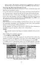
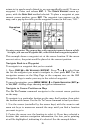
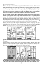
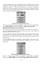
In the AirMap, airports have information screens packed with useful infor-
mation. They include much of the same information as a VOR information
screen. In addition, airport information screens contain a line drawing
showing the general layout of the airport's runways. Also, note that the ra-
dio frequencies listed at the bottom make a much longer list. You can press ↓
at the information screen to scroll down and see all of these frequencies.
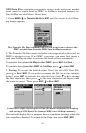
When you first open the airport information screen, you'll see "Go To"
highlighted at the bottom. You already know how to use
GO TO AND FIND
ON MAP, but airports have two more options: RUNWAYS and SERVICES.
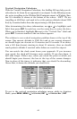
Airport information screen. Runways selected center, and Services at right.
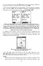
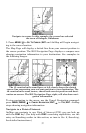
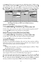
Runways
The Runways screen shows you everything AirMap knows about the
runways at the selected airport. Display boxes contain the runway sur-
face type, its length, its width and the light available.
Runways screen at left, with Extend option select. Center, map shows
the fan-shaped Runway Extension north of the airport. At right, you can
see where the runway extension begins at the very end of runway 18L.