


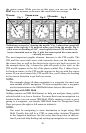
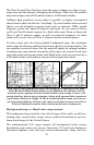

36
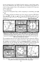
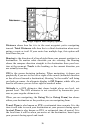
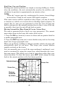
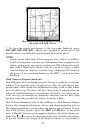
Map Page: Digital Data display option.
Distance shows how far it is to the next waypoint you're navigating
toward. Total Distance tells how far to a final destination when navi-
gating a route or trail. If your route has multiple legs, this option will
total them for you.
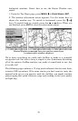
Bearing is the direction of a line-of-sight from your present position to a
destination. No matter what direction you are steering, the Bearing
shows the compass direction straight to the destination from your loca-
tion at the moment. Track is the heading, or the current direction you
are actually traveling.
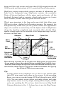
CDI is the course deviation indicator. When navigating, it shows you
graphically if you are to the left or right of the course (intended direction
or line of travel toward a destination). Steering "to the needle" will bring
you back on course. An alternate display is Off Course, which tells you
how far off course you are left or right in nautical miles.
Altitude is a GPS altimeter that shows height above sea level, not
ground level. The GPS altimeter is not corrected by barometric pres-
sure as your regular altimeter is.
When you are navigating, the Going To (or Going From) box shows
either your destination or the position you are navigating from.
Travel Time is also known as ETE, or estimated time enroute. It is the
time it will take to reach your destination at your present closing speed.
Arrival Time is also known as ETA, or estimated time of arrival. It is
the local time it will be when you arrive at the destination, based upon
your present closing speed and track.
Data boxes