


44
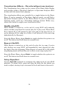
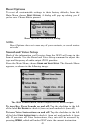
The GPS Status Screen contains several graphical elements that repre-
sent a lot of information.
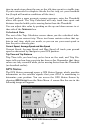
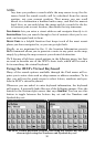
Current Position Lock
A set of three buttons along the left side of the screen indicates the
quality of position lock your iWAY currently has. The button that's se-
lected indicates your current position lock. If none of them is selected,
your current position hasn't been established.
2D means the iWAY has achieved a lock on your current position on a
map. A 2D lock does not include your altitude. The iWAY must receive
reliable signals from 3 satellites to establish a 2D lock.
3D means the iWAY has achieved a more reliable lock, including not
only your coordinate location but also your altitude (or elevation). The
iWAY must receive reliable signals from 4 satellites to establish a 3D
lock.
WAAS means your GPS is receiving reliable correction signals from the
FAA's Wide Area Augmentation System. WAAS is designed for use in
aircraft, but occasionally terrestrial vehicles can attain a WAAS lock.
This is the most accurate position signal available in the iWAY.
EPE (Estimated Position Error)
The Estimated Position Error (abbreviated "EPE") is shown right next
to the Current Position Lock buttons. This value represents the ex-
pected error from a benchmark location. In other words, if the EPE
shows 50 feet, then the position shown by the unit is estimated to be
within 50 feet of the actual location.
This also gives you an indicator of the fix quality the unit currently has.
The smaller the position error number, the better (and more accurate)
the fix is. If the position error flashes dashes, then the unit hasn't
locked onto the satellites, and the number shown isn't valid.
Satellite Display
A white circle that serves as a graphical view of the satellites overhead
fills much of the right half of the screen. Each satellite is shown on the
circular chart relative to your position. The GPS receiver is tracking sat-
ellites that are in blue type. The receiver hasn't locked onto a satellite if
the number is in dark blue, so it isn't being used to solve the position.
Lat/Lon Coordinates
Beneath the Satellite Display, you can see your Coordinates in Latitude
and Longitude. These numbers can be used to pinpoint your location on
any map, or to create contacts at your position on another GPS.