KMD 550/850 Appendix A
Rev 7 Sep/2005
A-1
APPENDIX A
DISPLAY ICONS
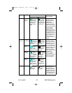
The following is a list of possible map icons on the TOPO ON Map and
TOPO OFF Map.
Feature Conditions Icon / Colors Other Characteristics
TOPO on TOPO off
Political
Boundary
Lines
Dashed
black
line
Not displayed When the 500 nm range
is selected, the name of
the political region will be
displayed with a white on
black label.
Railway
Lines
Dark gray
line with
hack marks
Not displayed May be enabled or dis-
abled based on Map
Setup page (3) setting.
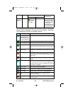
Roads Major Dark
gray
double line with
white on black
iconic label
Not displayed May be enabled or dis-
abled based on Map
Setup page (3) setting.
Prime Dark
gray line
with black on
white iconic
label
Not displayed May be enabled or dis-
abled based on Map
Setup page (3) setting.
Other Dark
gray
thin line with
black on white
iconic label
Not displayed May be enabled or dis-
abled based on Map
Setup page (3) setting.
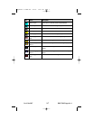
Victor
Airways
Thick
dashed
cyan line
with black on
white label
Thick
dashed
cyan line with
black on white
label
May be enabled or dis-
abled based on Map
Setup page (3) setting.
Highlighted when the line
is designated with the
joystick pointer. The
airway will be labeled
with the airway identifier.
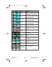
Heliroutes
Dashed blue
line with black
on white label
Dashed blue
line with black
on white label
May be enabled or dis-
abled based on Map
Setup page (3) setting.
Highlighted when the line
is designated with the
joystick pointer. The
heliroute will be labeled
with the heliroute name.
Appendix A ICONS R8 3/6/07 11:27 AM Page 1


