


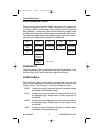

Simultaneously, boxes labeled PDIS and PBRG are displayed. These
show the distance and bearing from present position to the joystick
pointer. This function can be used to measure distance and bearing to
any point on the map. The window formed by the extremities of the
display can be moved around the map by "bumping" the display bor-
ders left, right, up or down with the pointer. The RNG
Δ
and RNG
∇
keys can still be used to zoom the map in and out. Press RESET
STICK and the joystick pointer will vanish, the display will return to the
moving map, and the map will be placed back in its present position at
the zoom level that was selected prior to activating the joystick. If the
joystick is not moved for 30 seconds, the display will time-out back to
the moving map.
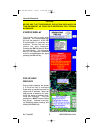
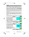
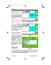
In addition to finding it useful for measuring distances and bearings,
the joystick can be used for other tasks. By placing the pointer over
any data icon and pressing MORE INFO, a display similar to Figure 5
will appear. Additional data and information on the selected item is
displayed.
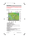
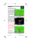
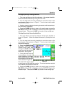
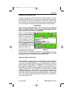
AIRPORT INFORMATION
As shown in Figure 6, you
can display airport informa-
tion by placing the joystick
pointer over an airport icon
and pressing MORE INFO.
All the information given here
is derived from the built-in
Jeppesen database.
Runway surfaces are shown
as an H for hard and an S for
soft. Lighting is shown as an
L for lit and a U for unlit.
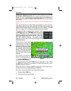
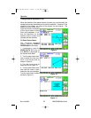
In addition to using the joy-
stick to get airport informa-
tion, the Control Knob may
also be used. Sometimes it
is not desirable to pan the
map to an airport location
some distance from the pre-
sent position. In this case
simply turn either knob and
the AIRPORT INFO Page
will appear as in Figure 6.
12
Rev 6 Jun/2004
KMD 550/850 Pilot's Guide
Operation
Figure 6
Figure 7
KMD 550-850 PG R8 3/6/07 11:22 AM Page 12