


Rev 7 Sep/2005 KMD 550/850 Pilot's Guide
7
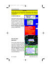
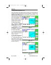
STORMSCOPE
®
OPTION
The KMD 550/850 has the ability to interface and control an L3 WX-500
or WX-1000E Stormscope
®
‘black box’ thunder storm sensor. When the
Stormscope
®
interface is on and the overlay is enabled, lightning icons
will also appear on the display.
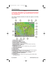
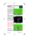
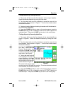
OBSTACLE LABELS
Obstacles are labeled with two numbers. The first number is the height
of the obstacle in FEET ABOVE MSL. The second number (in brackets)
is the height of the obstacle in FEET AGL.
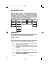
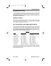
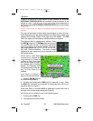
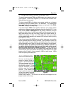
MAP TOPOGRAPHIC AND URBAN AREAS DISPLAY
On all TOPO ON map displays, the land is shaded to show rising ground
in seven elevation levels similar to those seen on a paper chart. In addi-
tion, all built up or urban areas are shaded light gray. Oceans, rivers and
lakes are blue. The levels and colors for the terrain shading vary with the
data card installed and are depicted as follows:
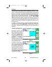
TERRAIN
Color Atlantic (MSL)
Americas & Pacific (MSL)
Light Green 0 - 499 feet 0 - 999 feet
Medium Green 500 - 999 feet 1000 - 1999 feet
Dark Green 1000 -1999 feet 2000 - 2999 feet
Light Brown 2000 - 2999 feet 3000 - 4999 feet
Medium Brown 3000 - 4999 feet 5000 - 8999 feet
Dark Brown 5000 - 8999 feet 9000 - 12999 feet
Dark Red 9000 feet and above 13000 feet and above
A color key can be displayed on the TOPO ON Map display. Move the
joystick pointer to any terrain area away from icons or control areas and
press the MORE INFO Key.
General Information
KMD 550-850 PG R8 3/6/07 11:22 AM Page 7