


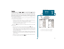
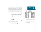

A
B
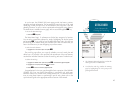
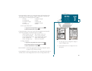
Map Modes
The map display uses the cursor keypad and a set of hard keys to control most
map display functions. The
C
and
D
keys, combined with the
R
keypad, let
you select zoom ranges and move the cursor. Two basic map operating modes,
position mode and cursor mode, determine what cartography is shown on the
map display. Position mode pans the cartography to keep the present position
marker within the display area, while cursor mode pans the cartography to keep
the cursor within the display area.
The GPSMAP system will always power up in the position mode, with your
vessel centered on the map display.
Whenever sufficient map coverage is not available to keep the boat cen-
tered, the boat icon will move toward the edge of the display.
If the boat icon attempts to go off the display, the zoom level may need to
be adjusted to keep cartography on screen.
Whenever the
R
keypad is pressed, the GPSMAP 180 will enter cursor mode.
In cursor mode:
The cursor can be moved over the map display using the
R
keypad.
Whenever the cursor reaches the edge of the display, the map will scroll
forward under the cursor. Keep in mind that the boat icon will move with
the map scrolling and may go off the display screen (you may not be able to
see your present position).
When the cursor is stationary, a fixed coordinate position will appear in the
position field. Note that the distance and bearing will change as the boats
position changes.
Whenever you zoom in cursor mode, the cursor will be centered on screen.
To return to position mode, press the
Q
key.
23
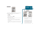
A. Position mode on inland water cartography.
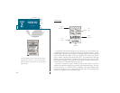
B. Cursor mode on inland water cartography.
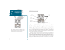
SECTION
3
MAP PAGE
Map Modes