


AB
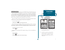
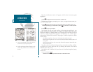
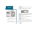
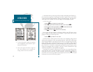
The GPSMAP 180s Satellite Page provides a visual reference of satellite acquisi-
tion and receiver status, with a signal strength bar graph and a satellite sky view in
the center of the page. Each page of the GPSMAP 180s system also features an
options page, which gives you access to other functions and features that relate to
the specific page you are viewing. To get a feel for how the options pages work,
lets put the GPSMAP 180 into simulator mode.
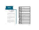
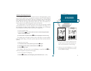
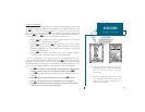
To place the GPSMAP 180 in simulator mode:
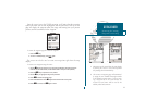
1. From the Satellite Page, press the
O
key. The options page will appear, displaying a
menu of options and functions for the Satellite Page.
2. Use the UP or DOWN arrow of the
R
keypad to highlight the Start Simulator? option and
press
T
.
3. Press the
T
key to confirm the simulator warning.
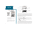
Once the simulator has been started, the status field at the top of the page will
display a Simulating Navigation status, and youre ready to continue the rest of
the tour. Keep in mind that the GPSMAP 180 does not track satellites in simulator
mode, and should never be used for actual navigation. All the waypoint and route
planning done in simulator mode will still be retained in memory for future use.
4
GETTING STARTED
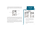
Satellite Page & Simulator Mode
A. To start the simulator, confirm the simulator
warning. Simulator mode should never be
used for actual navigation.
B. Whenever the GPSMAP 180 is in simulator
mode, a Setup Simulator? and an Exit
Simulator? option will appear on the options
page.
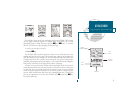
Status Field
Horizontal Accuracy
Satellite
Sky View
Signal Strength
Indicators
Status Bar
Dilution of Precision