


A
B
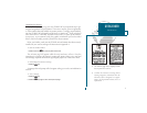
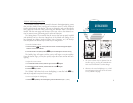
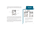
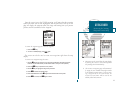
The GPSMAP 180s Map Page combines digital chartplotting with a user-selec-
table display of navigation data and a built-in worldwide database to 64 nm. It
will also be the page you use most to create and edit waypoints and routes. Before
we take off on our practice route, lets take a brief look at its various features and
displays.
The map display, located in the middle of the page, shows your boat as a trian-
gle marker on an electronically generated chart, along with geographic names,
markers and buoys that are provided by the G-chart cartridge youre currently
using. It also displays your track, routes and nearby waypoints. An on-screen
cursor lets you pan to other map areas, determine the range and bearing to a posi-
tion, and perform various waypoint and route functions.
The data window, located at the top of the page, provides a user-selectable dis-
play of various navigation data, including course, speed over ground, and the
bearing and distance to the cursor or a particular waypoint. The status bar, located
at the bottom of the page, displays the current map scale setting, as well as the sta-
tus information described on page 29.
7
GETTING STARTED
Map Page
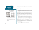
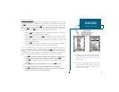
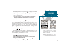
A. To select an on-screen waypoint, simply move
the cursor over the desired waypoint. The way-
point/navaid name and position, along with the
bearing and distance from your present posi-
tion, will be displayed.
B. The map page can also be configured to display
additional data fields and a graphic course devi-
ation scale or compass. See page 26 for more on
map options.
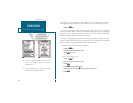
Boat
Icon
Data
Fields
Map
Scale