


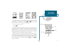
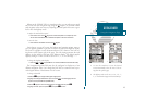

A
B
13
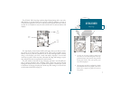
GETTING STARTED
Using the Navigation Page
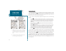
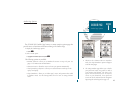
Whenever the GPSMAP 180 is in simulator mode, you can adjust your speed
and course from the Navigation Page using the
R
keypad. As you head toward
each waypoint in the tour route, try adjusting your boat speed and course to get a
feel for how the highway works.
To adjust the simulated boat speed:
1. Press the UP arrow of the
R
keypad to increase the speed in 5 knot/kph/mph incre-
ments. Press the DOWN arrow to decrease the speed in the same increments.
To steer the boat:
1. Press the LEFT and RIGHT arrows of the
R
keypad.
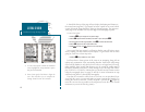
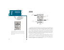
Notice that as you get off course, the highway and waypoint pointer move to
give you graphic guidance to get back on course. The base of the highway display
also serves as a graphic course deviation indicator (CDI), relative to the scale set-
ting shown at the bottom right of the page. The scale setting represents the total
distance (or the width) of the base of the highway display. The default graphic
highway setting is 1/4 nm, but can be set for a 1/2-, 1-, 2- or 4-nm range.
To change the highway scale display:
1. Press the
C
or
D
key (ZOOM OUT to increase, ZOOM IN to decrease the scale).
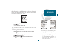
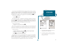
The Navigation Page data fields may also be configured to display any of ten
different navigation values. Lets change the VMG field to crosstrack error to pro-
vide a digital readout of the distance were off course.
To change a data field:
1. Press the
O
key to display the Navigation Page options.
2. Highlight the Change Data Fields? option and press
T
. The field highlight will now
appear in the top-left data field (the BRG field).
3. Use the
R
keypad to move the field highlight to the VMG field and press
T
.
4. Highlight the XTE option and press
T
, and press
Q
to finish.
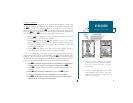
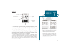
A. To reset the simulator to steer the desired
course automatically, select the Auto COG set-
ting from the options page.
B. The highway scale can be set to a 1/4-, 1/2-, 1-,
2-, or 4-nm/mi/km range with the ZOOM keys.