


50 GPSMAP 5000 Series Owner’s Manual
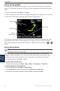
Using Radar
USinG
radar
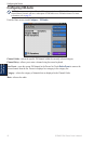
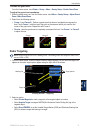
Conguring Other Vessels on the Radar Screen
You can congure which other vessels are displayed on the radar screen. From the Radar screen,
touch Menu > Other Vessels.
NOTE: To congure Automatic Identication System (AIS) information for other boats, your
chartplotter must be connected to an external AIS device.
List—display a list of AIS and MARPA threats. Touch Show to select between displaying AIS or
MARPA
threats, or All Threats.
Display Setup—congure how other vessels are displayed on the Radar screen.
Display Range—set the distance from your location that AIS vessels are displayed.
Details—show or hide details for each vessel.
Proj. Heading—set the projected heading time.
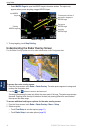
Collision Alarm
(AIS and MARPA only)—turn a safe zone around your boat on or off. This is used
for collision avoidance, and can be customized.
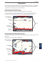
To customize safe-zone settings for the Collision Alarm:
1. From the Radar screen, touch Menu > Other Vessels > Collision Alarm.
2. Select from the following options:
Range—change the measured radius of the safe zone ring to a specied distance from 500 ft.
to 2.0 nm (or from 150 m to 3.0 km, or from 500 ft. to 2.0 mi).
Time To (Safe Zone)—sounds an alarm if AIS or MARPA determines that a target will
intersect the Safe Zone within the dened time interval (ranging from 1 to 24 minutes).
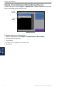
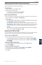
Advanced Radar Conguration
To access advanced radar settings, from the Radar screen, touch Menu > Radar Setup.
Rotation Speed (GMR 18/24/404/406 series models only)—set the rotation speed of your radar to
Normal Speed or High Speed. High Speed increases the speed at which the antenna rotates, which
increases the speed at which the screen updates.
Front of Boat—offset the front of the boat if you mount the radar at an angle.
Data Bars—show or hide cruising, navigation, shing, fuel, or sailing numbers (page 7).
Appearance
—congure radar display options.
Color Scheme—change the colors used for the radar display.
Orientation
—change the perspective of the radar display.
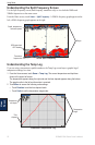
Look-Ahd Spd—
shift your current location toward the bottom of the screen as your speed
increases. Enter your top speed for the best results.
Heading Line—show or hide a line in the direction of travel.
Rings—show or hide the radar range rings.
Nav Lines—show or hide a colored line that indicates the route you are currently navigating.
Waypoints—show or hide waypoints that are within the range displayed on the Radar screen.
Touch Navigation Only to display only waypoints associated with the currently active route.
•
•
•
•
•
•
•
•
•
•
•
•