


14 GPSMAP 5000 Series Owner’s Manual
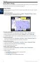
Using Charts
USinG
ChartS
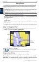
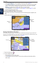
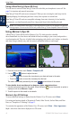
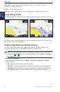
Using Radar Overlay
When you connect your chartplotter to an optional Garmin marine radar, you can use Radar Overlay
to overlay radar information on the Navigation chart (page 48).
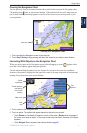
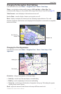
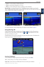
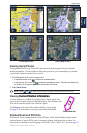
Using Tracks
A track is a recording of your path. The track currently being recorded is the active track. An active
track can be saved.
To turn the track log on:
From the Navigation or Perspective 3D chart, touch Menu > Waypoints & Tracks > Tracks >
On. A trailing line on the chart indicates your track.
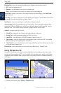
To save the active track:
1. From the Home screen, touch Information > User Data > Tracks > Save Active Track.
2. Select an option: the time the current track began or Midnight, if shown; or Entire Log.
3. Touch Edit Track to name the track, to change the color of the track, or to save it as a route.
To clear the active track:
From the Home screen, touch Information > User Data > Tracks > Clear Active Track. The
track memory is cleared; the current track continues to be recorded.
To retrace the active track:
1. From the Home screen, touch Information > User Data > Tracks > Follow Active Track.
2. Select either the time the current track began or Entire Log.
3. Follow the colored line on the screen.
To edit or delete a saved track:
1. From the Home screen, touch Information > User Data > Tracks > Saved Tracks.
2. Select a track to edit or delete.
3. Select an option:
Touch Edit Track to change the name or color of the track.
Touch Delete to delete the track.
Touch Next Page to view information about the track.
•
•
•