


6 GPSMAP 5000 Series Owner’s Manual
Using Charts
USinG
ChartS
Using Charts
The GPSMAP 5000 series chartplotters have a basic worldwide imagery map and built-in detailed
BlueChart g2 offshore cartography for US waters. The following options are available when you
touch Charts on the Home screen:
Navigation Chart—displays navigation data available on your preloaded maps, including buoys,
lights, cables, depth soundings, marinas, and tide stations in an overhead view.
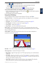
Perspective 3D—displays a view from above and behind your boat for a visual navigation aid.
NOTE: Mariner’s Eye 3D, Fishing Charts and Fish Eye 3D views are available when using optional
Blue Chart g2 Vision preprogrammed SD cards. See page 16.
Mariner’s Eye 3D—displays a detailed, three-dimensional view from above and behind the boat
for a visual navigation aid.
Fishing Chart—removes navigational data from the chart and enhances bottom contours for
depth recognition.
Fish Eye 3D—provides an underwater view that visually represents the sea oor according to the
chart’s information.
The chartplotter selectively displays navigation data after you select the type of navigation you want.
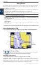
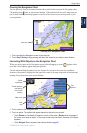
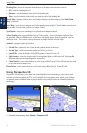
Using the Navigation Chart
Use the Navigation chart to plan your course, to view map information, and as a navigational aid.
From the Home screen, touch Charts > Navigation Chart.
Navigation Chart on a GPSMAP 5208
Buoy
Your boat
Marine
services
Zoom scale
Light
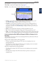
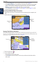
Zooming In and Out on the Map
The and keys control the zoom level, indicated by the scale at the bottom of the Navigation
chart ( ). The bar under the number represents that distance on the map.
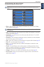
Navigation Chart Settings
To access additional settings or options for the Navigation chart, touch Menu.
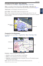
Waypoints & Tracks
—view and add waypoints and tracks, and congure how they are displayed.
Other Vessels
—view information about other vessels if your chartplotter is connected to an external
Automatic Identication System (AIS) or Digital Selective Calling (DSC) device.
•
•
•
•
•