


GPSMAP 5000 Series Owner’s Manual 17
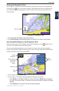
Using Charts
USinG
ChartS
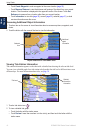
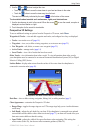
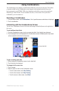
Classic—use color schemes to indicate 3D terrain.
Charts—provide chart information in a 3D view.
Photos—provide satellite photo imagery in addition to chart information.
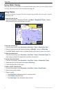
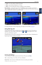
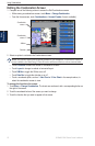
Hazard Colors—turns hazard colors on or off. The Off setting shows the land as seen from the
water. The On setting indicates shallow water and land with a color scale. Blue indicates deep water,
yellow is shallow water, and red is very shallow water.
Mariner’s Eye 3D, Normal Colors Mariner’s Eye 3D, Hazard Colors
For settings and options related to Range Rings, Safe Depth, and Lane Width, see page 11.
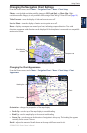
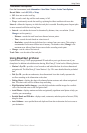
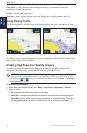
Using Fish Eye 3D
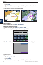
Using the depth contour lines of the BlueChart g2 Vision cartography, Fish Eye 3D provides an
underwater view of the sea oor or lake bottom. The and buttons adjust the view in the
same way as the Mariner’s Eye 3D.
Suspended targets (such as sh) are indicated by red, green, and yellow spheres. Red indicates the
largest targets and green indicates the smallest.
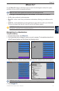
Fish Eye 3D
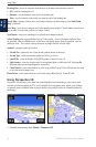
Fish Eye 3D Settings
To access additional settings or options for the Fish Eye 3D screen, touch Menu.
View—selects a sh-eye view of Fore, Aft, Port, or Starboard.
Sonar Cone—turns a cone on or off that shows the area covered by your transducer.
•
•
•