


30 GPSMAP 198C Sounder Owner’s Manual
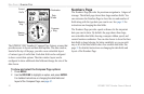
MAIN PAGES > MAP PAGE
The GPSMAP 198C Sounder’s system has a built-in worldwide
database to 20 mi, with more detailed coverage available through
the use of the optional BlueChart or MapSource data. The
GPSMAP 198C Sounder shows cartography as long as there is
chart information available for the range you have selected. Map
coverage conforms to the following conditions:
• When the selected zoom range is covered by the internal
database, BlueChart, or MapSource data, cartography is
shown.
• When the selected zoom range is covered by both
the internal database and BlueChart/MapSource data,
cartography is shown using the data with the best resolution.
• When the selected zoom range exceeds the resolution of the
data in use, an Overzoom warning appears below the zoom
range.
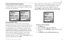
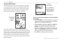
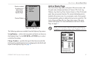
Map Page Options
Many features of the GPSMAP 198C Sounder are menu driven.
Each main page has an options menu, allowing you to customize
the corresponding page to your preferences and/or select special
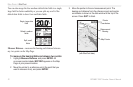
features that specifically relate to that page. The data window,
located at the top of the main pages, provides a user-selectable
layout of various types of useful data. Each data field can be
configured to show any one of several data options. The data
window layout can be configured to show additional data fields and
change the size of the data shown.
The GPSMAP 198C Sounder’s Map Page provides access to
functions and features relating to the Map Page and layout options.
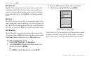
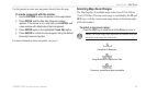
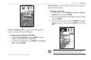
To show and select the Map Page options:
1. Press MENU.
2. Use the ROCKER to highlight an option, and press ENTER.
The available options are Full Screen Map/Show Data, Change
Numbers, Measure Distance, Show Sonar (If equipped with a
transducer, see the “Using Sonar” section on page 78 for details on
this feature,) Set up Map and Turn Declutter On/Off. Following are
details on using each of these options.