


GPSMAP 198C Sounder Owner’s Manual 27
MAIN PAGES > MAP PAGE
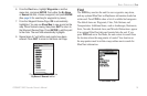
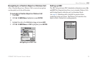
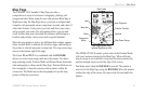
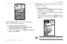
Map Page
The GPSMAP 198C Sounder’s Map Page provides a
comprehensive screen of electronic cartography, plotting, and
navigational data. When using the unit with optional BlueChart or
MapSource data, the Map Page shows your boat on a digital chart,
complete with geographic names, map items, navaids, and a host of
other chart features. It also plots your track and shows any routes
and waypoints you create. The map pointer allows you pan and
scroll to other map areas, determine the distance and bearing to a
location, and perform various route and waypoint functions.
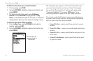
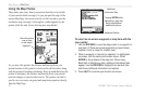
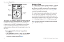
When the map pointer is active, an additional data window appears
below the data fields to indicate the location, range, and bearing to
the pointer, a selected waypoint, or map item. The map zoom range
shown at the bottom right of the page.
The Zoom IN and OUT keys combined with the ROCKER,
allows you select zoom ranges and move the pointer. Two basic
map operating modes, Position Mode and Pointer Mode, determine
what cartography is shown on the Map Page. Position Mode moves
the cartography to keep the present position marker within the
screen area. Pan Mode moves the cartography to keep the map
pointer within the screen area.
Data Fields
Position Triangle
Map Zoom Range
Land
Water
Geographic
Name
Map Item
Navaids
User Waypoint
Map Page shown using
optional MapSource data.
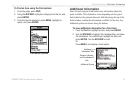
The GPSMAP 198C Sounder system starts in the Position Mode,
with your location centered on the Map Page. When sufficient
map coverage is not available to keep your location centered, the
position triangle moves toward the edge of the screen.
Pan Mode starts when the ROCKER is pressed. The pointer is
moved over the Map Page using the ROCKER. When the pointer
reaches the edge of the screen, the map scrolls forward under the
pointer.