


Northstar M121/M84 Installation and Operation Manual26
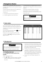
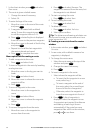
6 Navigation: Waypoints
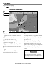
A waypoint is a position that you can set on the
Instrument chart, for example a fishing spot or
a point on a route. The Instrument can have up
to 3000 waypoints. A waypoint can be created,
changed or deleted.
A waypoint has:
A name (up to eight characters).
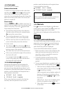
An icon showing what kind of waypoint it is.
The available icons are:
A position.
A color for the waypoint symbol and name
on the chart.
A type:
Normal: A normal waypoint can be
navigated to or included in a route.
Danger: A danger waypoint is a point
to avoid. If the boat comes within the
danger radius of a danger waypoint the
unit can sound an alarm
(see section 19-10).
A display option:
Controls how the waypoint is displayed on
the chart (see section 19-2):
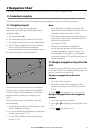
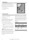
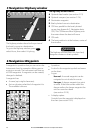
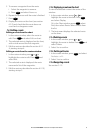
5 Navigation: Highway window
The highway window shows:
A Optional data header (see section 2-7-3)
B Optional compass (see section 2-7-4)
C Destination waypoint
D Boat’s plotted course to destination
E CDI lines, parallel to the boat’s plotted
course (see Appendix C, Navigation data,
CDI). The CDI lines are like a highway over
the water where the boat will move
F CDI scale
G The boat position is at the bottom, centre of
the window
!
WARNING
The highway window does not show land,
dangerous waters or chart symbols.
G
The highway window has a bird’s eye view of
the boat’s course to a destination:
To go to the Highway window, press
DISPLAY
,
select More, then select Highway.
E
D D
F
C
A
B