


81
MN002000A © 2004 Navman NZ Ltd. All rights reserved. Proprietary information and specifications subject to change without notice.
APPENDIX D: Frequently Asked
Questions (FAQ)
This appendix provides answers to frequently
asked questions about GPS in general and about
the Jupiter series of GPS receivers, it is intended
to supplement the operational description provided
in section 4.0 of this document.
1. How far and under what conditions can a passive
antenna track before it is necessary to change it to
an active antenna?
There is no simple answer to this question.
Navman generally recommends limiting cable loss
to 3 dB between the antenna and the receiver
board. If attenuation exceeds this value there may
be degraded signal acquisition and navigation
accuracy performance. GPS satellites transmit
more power than their specification requires, but
that margin is allocated to the 3 dB cable loss. The
safest approach is to use an active antenna unless
the antenna and receiver engine are co-located.
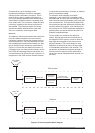
2. Can the Jupiter receiver operate efficiently in an
urban location with tall structures and buildings?
Yes. By using 12 parallel channels, Jupiter
receivers maintain continuous tracking of all
visible satellites and produce an over-determined
solution, minimising the effects of signal blockage
and giving optimal performance in dense urban
environments.
3. Is there any danger to the receiver when
switching is done between active and passive
antennas?
Yes. If pre-amp power is supplied to an active
antenna and then connected to a passive antenna
there is a high probability of damage since the
passive antenna often presents a short circuit to
ground at DC. This then shorts out the pre-amp
power line and destroys the bias-tee network on
the receiver.
4. What is the criteria for choosing satellites for
navigation if more than four are visible?
The Jupiter receiver continuously tracks all visible
satellites. The measurements from these satellites
are used in an over-determined solution to provide
the most robust performance that is possible.
5. What is the accuracy of GPS with selective
availability turned on? How is the accuracy affected
by DGPS?
The U.S. Government guarantees that horizontal
accuracy will be less than 100 m (95% of the
time) and less than 300 m (99.99% of the time).
Accuracy with DGPS is primarily a function of the
quality and latency of the corrections used.
6. What is the difference between the two models
for position determination used in GPS: WGS 84
and Earth-Centred-Earth-Fixed (ECEF)?
ECEF refers to a Cartesian (rectangular)
coordinate system (x,y,z,) whose centre is at the
middle of the Earth; one axis goes through the
North Pole, one through the Greenwich meridian
at the equator, and the third passes through the
equator 90 degrees offset from the second. This
system rotates with the Earth. GPS satellites
broadcast their location in this coordinate system.
WGS-84 contains a mathematical model of the
Earth’s surface (spheroid) which is accepted
worldwide. However, the model does have some
limitations. For example, 0 m altitude may differ
from mean sea level in this model by up to ~100 m.
Position in WGS-84 is specified in latitude and
longitude and by the altitude above the WGS-84
spheroid (Earth surface model).
7. What are the addresses for U.S. FM DGPS service
providers?
• ACCQPOINT Communications Corp. 2737,
Campus Drive, Irvine, CA 92715, (800) 995-3477
• Differential Corrections Inc. (DCI) 10121 Miller
Avenue, Cupertino, CA 95014, (408) 446-8350
8. Does the Jupiter receiver provide an over-
determined solution?
Jupiter receivers provide all-in-view parallel
tracking of all visible satellites. In SPS mode
all valid measurements are used to produce an
over-determined navigation solution to minimise
position excursions arising from SA and loss of
signals. In DGPS all valid measurements with valid
DGPS corrections are used in an over-determined
solution. For example, if 8 satellites are in track,
all producing valid measurements, and DGPS
corrections are available for 7 of the 8, then 7
DGPS corrected measurements will be used in the
over-determined DGPS solution.
9. How is heading data at low speeds derived?
Shouldn’t the heading be derived from Doppler data
rather than position differences?
Navman receivers compute velocity from the
carrier loop Doppler information. Heading angle
is then computed from east and north velocity
as the arc-tangent (Ve/Vn). When on, SA
induces an error on the GPS clock and thus the
carrier Doppler information and pseudo-range is
corrupted, but the carrier data is a better source of
velocity information than position differences. The
worst heading error at 5 m/s is 1.1 degrees when
SA is off or DGPS is on. All heading determination
techniques using GPS velocities have large
uncertainties at small velocities when the velocity
approaches the magnitude of the inherent noise.