


49
MN002000A © 2004 Navman NZ Ltd. All rights reserved. Proprietary information and specifications subject to change without notice.
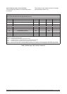
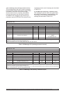
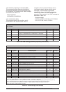
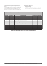
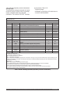
Message ID: ERR
Rate: variable
Fields: 3
Field No. Symbol Field description Field type Example
$-- --ERR Start of sentence and address field $PRWIERR
1
Class: 0 = user mode exception, 1 = executive mode exception,
2 = trap, 3 = executive error, 4 = ESR error, 5 = user error
x.x
0
2 Exception, trap, or error number x.x 0
3 Word address of condition hhhhhh 005BC9
CKSUM Checksum *hh *01
<CR><LF> Sentence terminator <CR><LF>
Table 3-46. ERR message (Navman proprietary error/status)
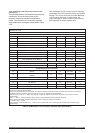
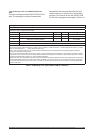
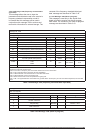
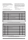
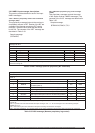
Message ID: GGA (while receiver is in navigation mode, see Note 1)
Rate: variable; defaults to 1 Hz
Fields: 14
Field No. Symbol Field description Field type Example
$--GGA Start of sentence and address field $GPGGA
1 POS_UTC UTC of position (hours, minutes, seconds, decimal seconds) hhmm.ss.ss 222435
2 LAT Latitude 1111.11 3339.7334
3 LAT_REF Latitude direction (N = north, S = south) a N
4 LON Longitude yyyyy. yy 11751.7598
5 LON_REF Longitude direction (E = east, W = west) a W
6 GPS_QUAL GPS quality indicator (Note 2) x 2
7 NUM_SATS Number of satellites in use, 00 to 12 xx 06
8 HDOP Horizontal dilution of precision x.x 1.33
9 ALT_MSL Antenna altitude above/below mean sea level (geoid) (Note 3) x.x 27.0
10
M Units of antenna altitude (metres) m M
11 GEOID_SEP Geoidal separation (Note 4) x.x –34.4
12
M Units of geoidal separation (metres) m M
13 DGPS_AGE Age of differential GPS data (Note 5) x.x
7
14 STA_ID Differential reference station ID (0000 to 1023) (Note 6) xxxx 0000
CKSUM Checksum *hh *41
<CR><LF> Sentence terminator <CR><LF>
Note 1: When the navigation solution is invalid, fields 1 to 5 and 8 to 14 are null. Field 7 also has special meaning (see Note 3).
Note 2: GPS quality indicator: 0 = fix not available or invalid; 1 = GPS fix; 2 = DGPS fix.
Note 3: The geodetic altitude can be computed from the mean sea level altitude by adding the geoidal separation (word 11).
Note 4: Geoidal separation is the difference between the WGS-84 Earth ellipsoid and mean sea level (geoid).
Note 5: Time in seconds since the last SC1-04 Type 1 or Type 9 update; null field when DGPS is not used.
Note 6: This field is null when DGPS is not used.
Table 3-47. GGA message (GPS fix data)
3.6.1.2 Navman proprietary error/status (ERR)
This message provides diagnostic information if
the receiver encounters an error during execution
of its firmware. The contents of the ‘ERR’ message
are described in Table 3-46.
Sample message:
$PRWIERR,0,0,005BC9*0l
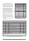
3.6.1.3 GPS fix data (GGA)
This message contains time, position, and fix
related data for the Jupiter receiver. When a
navigation solution passes all validity criteria
(set using the binary ‘solution validity criteria’
message), a GGA message is generated
automatically. If any of the validity criteria are
invalid for the solution, a GGA message is not
generated. The contents of the ‘GGA’ message are
described in Table 3-47.
Sample message:
$GPGGA,222435,3339.7334,N,11751.7598,W,
2,06,1.33,27.0,M,-34.4,M,7,0000*41