


81
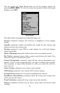
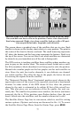
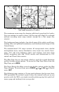
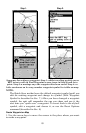
Far left, Map Page opening screen. Center, zoomed to 100 miles
and right, zoomed to 15 miles.
The maximum zoom range for showing additional map detail is 8 miles.
You can continue to zoom in closer, but the map will simply be enlarged
without revealing more map content (except for a few major city
streets).
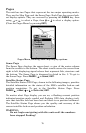
The background map includes: low-detail maps of the whole world (con-
taining cities and political boundaries); and medium-detail maps of the
United States.
The medium-detail U.S. maps contain: all incorporated cities; shaded
metropolitan areas; county boundaries; some major city streets; Inter-
state, U.S. and state highways; lakes and streams; and more than
60,000 navigation aids and 10,000 wrecks and obstructions in U.S.
coastal and Great Lakes waters
The Map Page has its own menu, which is used for several functions
and for setting various options. To access the Map Page Menu, from the
Map Page, press
MENU.
The Pages Menu also offers several map display options under the Map
Page category. To access them, press
PAGES|← or→ to MAP|↓ to Option
name|
EXIT.
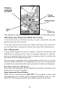
The following page contains a 12-step quick reference for the most basic
GPS operations. If you don't want to carry the manual with you as you
practice with the M56, you might consider photocopying this quick ref-
erence page and tucking it into your pocket.