


76
Pages
The unit has two Pages that represent the two major operating modes.
They are the Map Page and the Sonar Page. Each Page has several sub-
set display options. They are accessed by pressing the
PAGES key, then
using → or ← to select a Page, then ↑ or ↓ to select a display option.
(Clear the Pages Menu by pressing
EXIT.)
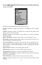
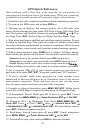
Pages Menu, showing some Map display options.
Sonar Page
The Sonar Page displays the sonar chart, a view of the water column
from the surface to the bottom. The chart scrolls across the screen from
right to left, displaying signal echoes that represent fish, structure and
the bottom. The Sonar Page is discussed in detail in Sec. 3. To get to
the Sonar Page: Press
PAGES|→ to SONAR|EXIT.
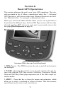
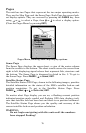
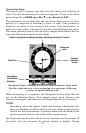
Satellite Status Page
The Satellite Status GPS Page, shown in the following images, provides
detailed information on the status of the M56's satellite lock-on and
position acquisition. To get to the Satellite Status Page: Press
PAGES|← to MAP|↑ or ↓ to SATELLITES|EXIT.
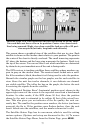
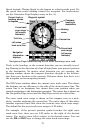
No matter what Page display you are on, a flashing current position
indicator/question mark symbol and flashing GPS data displays indi-
cate that satellite lock has been lost and there is no position confirmed.
The Satellite Status Page shows you the quality and accuracy of the
current satellite lock-on and position calculation.
WARNING:
Do not begin navigating with this unit until the numbers
have stopped flashing!