


69
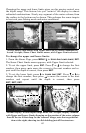
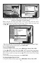
2. Press ↓ or ↑ to select Data Type|press → or ← to Data Size|
EXIT
.
The selected data type will be displayed in the new size. (To change the
font size for another Data Type, press
ENT
and repeat these steps, be-
ginning with step two above.)
3. To return to the previous page, press
EXIT
.
Tip:
If you wish, you can change the displayed data font size when you
select a data type:
1. From the Map or Sonar page, press
MENU
|↓ to
O
VERLAY
D
ATA
|
ENT
.
2. Press ↓ or ↑ to select Data Type|press → or ← to select Data
Size|
ENT
.
The data will be shown in the new font size. To return to the previ-
ous page, press
EXIT
|
EXIT
.
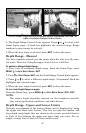
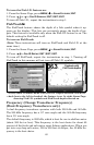
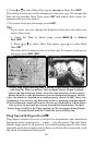
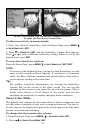
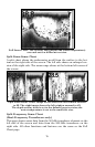
At left, Map Page showing boat cruising Puget Sound, Washington,
with Overlay Data turned on. This example shows Depth, Ground
Speed and the Steering Arrow. Note that the Steering Arrow always
points directly to the destination you are navigating toward. In this
case, the boater is headed on a northwesterly course of 280º. Since the
helmsman is on course, the Steering Arrow is pointing straight ahead.
If the helmsman veered off course, the arrow would show which direc-
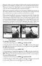
tion to steer to get back on course toward the destination. At right,
Sonar Page with Overlay Data turned on. This example shows Depth,
Ground Speed and the Track the boat is following.
Ping Speed & HyperScroll
Ping Speed controls the rate at which the transmitter and transducer
broadcast sonar sound waves — pings — into the water. The unit has a
default ping speed of 50 percent. At normal boating speeds, this auto-
matically provides enough return echoes to refresh the screen and scroll
the chart at maximum chart speed.
Steering
arrow
Course
line