


143
tion) or from a stored waypoint, map place or POI location (
C
HOOSE
S
TART
command). You can steer your position and change speed on the map by
using the arrow keys (
S
TEER WITH
A
RROWS
command) or by setting the track
and speed in the dialog boxes provided on the simulator menu screen.
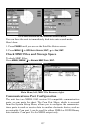
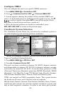
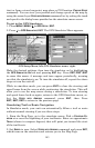
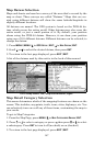
To get to the GPS Simulator:
1. Press
MENU
|
MENU
|↓ to
GPS S
ETUP
|
ENT
.
2. Press ↓ to
GPS S
IMULATOR
|
ENT
. The GPS Simulator Menu appears.
GPS Setup Menu, left; GPS Simulator menu, right.
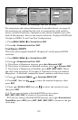
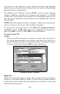
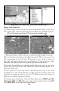
Make the desired settings, then turn the simulator on by highlighting
the
GPS S
IMULATOR
O
N
box and pressing
ENT
key. Press
EXIT
|
EXIT
|
EXIT
to erase this menu. A message and tone appear periodically, warning
you that the simulator is on. To turn the simulator off, repeat the above
steps or turn the unit off.
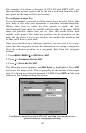
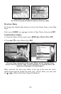
While in simulator mode, you can press
EXIT
to clear the steering and
speed boxes from the screen while continuing the simulation. This will
allow you to use the map cursor during a simulation. To turn steering
and speed boxes back on again, return to the GPS Simulator menu, se-
lect the
S
TEER WITH
A
RROWS
command, press
ENT
, then Press
EXIT
|
EXIT
|
EXIT
to return to the previous page.
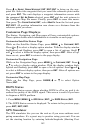
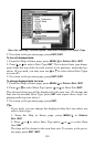
Simulating Trail or Route Navigation
In Simulator mode, your unit can automatically follow a trail or route
without manual steering if you use these steps:
1. From the Map Page, go to the simulator menu. Pick a
S
TARTING
P
O-
SITION
at or near the beginning of your trail/route. Enter an approximate
T
RACK
(shown in compass degrees) that will point you toward the start
of the trail/route.
2. Set
S
PEED
to zero. Select
S
TEER WITH
A
RROWS
command and press
ENT,
which turns on the simulator and returns you to the Map Page.