


151
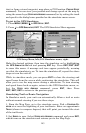
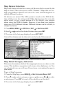
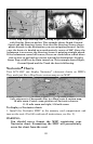
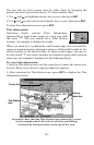
At left, Map Page showing boat cruising Puget Sound, Washington,
with Overlay Data turned on. This example shows Depth, Ground
Speed and the Steering Arrow. Note that the Steering Arrow always
points directly to the destination you are navigating toward. In this
case, the boater is headed on a northwesterly course of 280º. Since the
helmsman is on course, the Steering Arrow is pointing straight ahead.
If the helmsman veered off course, the arrow would show which direc-
tion to steer to get back on course toward the destination. At right,
Sonar Page with Overlay Data turned on. This example shows Depth,
Ground Speed and the Track the boat is following.
Navionics
Charts
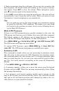
Your LCX-104C can display Navionics
electronic charts on MMCs.
They work just like a MapCreate custom map on an MMC.
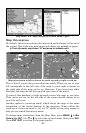
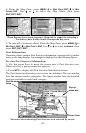
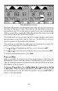
Left, entrance to Chesapeake Bay in a MapCreate 6 custom map,
10 mile zoom. Center, same position on Navionics chart at
11.15 mile zoom and right, 5.56 mile zoom.
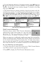
To display a Navionics chart:
1. Install the Navionics MMC in the memory card compartment and
turn on the unit. (For full card install instructions, see Sec. 2.)
WARNING:
You should never format the MMC containing your
Navionics chart. Formatting the MMC will permanently
erase the chart from the card.
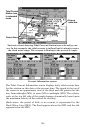
Steering
arrow
Course
line