


54
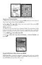
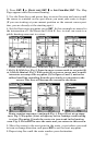
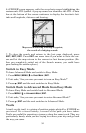
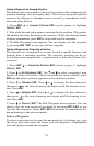
6. iFINDER's map appears, with the cross-hair cursor highlighting the
restaurant's POI symbol. A pop-up name box identifies the POI. A data
box at the bottom of the screen continues to display the location's lati-
tude and longitude, distance and bearing.
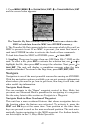
Map screen showing Finding Waypoint,
the result of a lodging search.
7. To clear the search and return to the last page displayed, press
EXIT|EXIT|EXIT. Press EXIT one more time if you want to clear the cur-
sor and let the map return to the current or last known position. (Be-
fore you completely exited out of the Search menus, you could have
gone looking for another place.)
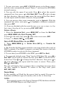
Switch to Easy Mode
To leave Advanced Mode and switch to Easy Mode:
1. Press
MENU|MENU|↓ to EASY MODE|ENT.
2. Unit asks, "Are you sure you want to turn on Easy Mode?"
3. Press ←|
ENT and the unit switches to Easy Mode.
Switch Back to Advanced Mode from Easy Mode
To leave Easy Mode and switch back to Advanced Mode:
1. Press
MENU|↓ to ADVANCED MODE|ENT.
2. Unit asks, "Are you sure you want to enter Advanced Mode?"
3. Press ←|
ENT and the unit switches to Advanced Mode.
Trails
A trail, or plot trail, is a string of position points plotted by iFINDER as
you travel. It's a travel history, a record of the path you have taken.
Trails are useful for repeating a journey along the same track. They are
particularly handy when you are trying to retrace your trip and go back
the way you came.