


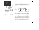
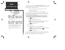
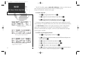


The GPS 155 position page displays your present latitude and longitude, altitude
and a reference waypoint field; and is also used to enter barometric pressure during
approach operations. The altitude and reference waypoint fields are selectable to con-
figure the page to your own preferences and current navigation needs.
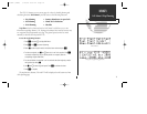
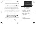
The altitude field can display either the present altitude, minimum safe altitude
(MSA) or the enroute safe altitude (ESA). MSA is the recommended minimum altitude
within approximately ten miles of your present position. ESA is the recommended
minimum altitude within ten miles of your course on an active route or direct-to.
MSA and ESA altitudes are calculated from information contained in the database and
generally includes mountains, buildings and other permanent features (see right).
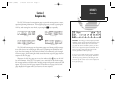
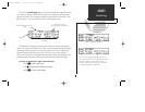
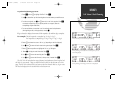
To change the altitude field to display other information:
1. Press
C
to obtain a flashing cursor.
2. Use
K
to change the field to display the desired data.
3. Press
C
to return to normal navigation.
11
NAV KEY
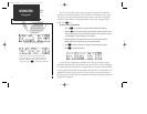
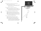
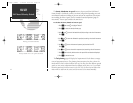
Position Page
Position page displaying MSA.
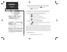
The same Position page displaying ESA. If you are on a
route from New York City to Los Angeles, the MSA would
be 2700 ft. at KJFK to account for objects in the area.
However, the ESA would be 16,700 feet to account for the
course flying through the Rocky Mountains.
Altitude, MSA or ESA (selec-
table)
Barometric Pressure
(during approach navigation)
Position
Waypoint Reference Field
(selectable)
155man (GOOD) 7/24/98 1:56 PM Page 11