


85
Reference
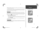
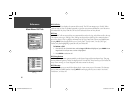
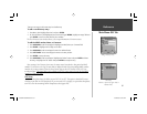
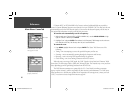
Main Menu: Units Tab
For additional information on Loran TD setup, see page 102.
• Map Datum – allows you to manually select the datum reference used to determine a given posi-
tion. The default setting is ‘WGS 84’. The unit automatically chooses the best datum depending
upon your chosen position format. Datums are used to describe geographic positions for surveying,
mapping, and navigation and are not actual maps built in the unit. Although over 100 datums are
available (as listed on page 104), you should only change the datum if you are using a map or chart
that specifi es a different datum.
WARNING: Selecting the wrong map datum can result in substantial position errors.
• Heading – lets you select the reference used in calculating heading information. You can select from
‘Auto Mag Var’, ‘True’, ‘Grid’ and ‘User Mag Var’. ‘Auto Mag Var’ provides magnetic north heading
references which are automatically determined from your current position. ‘True’ provides headings
based upon a true north reference. ‘Grid’ provides headings based on a grid north reference (and
is used in conjunction with the grid position formats described on page 84). ‘User Mag Var’ allows
you to specify the magnetic variation at your current position and provides magnetic north heading
references based upon the variation you enter.
To enter a user defi ned magnetic variation:
1. With the Heading fi eld set to ‘User Mag Var’, highlight the heading reference fi eld (immediately to the
right) and press ENTER.
2. Use the ARROW KEYPAD to enter the magnetic variation at your current position and press
ENTER.
• Distance, Speed and Elevation – lets you select the desired units of measure for distance, speed and
elevation readouts in ‘Nautical’ (nm, kt, ft), ‘Nautical’ (nm, kt, m), ‘Statute’ (mi, mh, ft) or ‘Metric’
(km, kh, m) terms.
• Depth – lets you select the desired units of measure for depth in Feet (ft), Fathoms (fa) or Meters (m).
• Temperature – lets you select the desired units of measure for temperature in Fahrenheit (°F) or
Celsius (°C).
,
WARNING: If ‘User Mag Var’ is selected, you must
periodically update the magnetic variation as your position
changes. Using this setting, the unit does not automati-
cally calculate and update the magnetic variation at your
present position. Failure to update this setting may result in
substantial differences between the information displayed
on your unit and external references, such as a magnetic
compass.
,
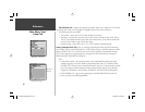
The Units tab settings affect how navigation information
is displayed on the GPSMAP 178C. When in doubt, seek
assistance.
If you are using a map or chart in conjunction with your
GPS, make sure the settings under the ‘Units’ tab of the
GPSMAP 178C match that of the map or chart. This infor-
mation should be displayed somewhere on the map or chart.
If the information is not present, contact the map or chart
maker to determine what position format, datum, heading
and units of measure are being used for the map or chart.
,
GPSMAP178CManual.indd 85 3/19/2004, 3:10:47 PM