


9
Getting Started
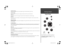
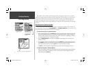
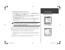
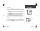
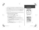
Map Cursor
Using the Map Cursor
Working from the Map Page is a simple process that centers around the use of the cursor. Con-
trolled by the ARROW KEYPAD, the cursor is an important tool that can be used to pan to other map
locations, mark and edit waypoints and routes, and review position data of on-screen map items and
waypoints.
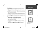
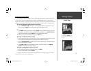
To get a feel for using the Map Page and using the cursor, try the following exercise:
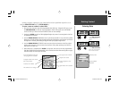
1. Use the IN/OUT keys to set the map scale to the 50 nm setting. Your boat should be near the
center of the map, at the receiver’s last known position. (If your boat isn’t where it should be, make
sure that you have initialized the receiver and acquired a position as described on pages 4-5.)
2. Use the ARROW KEYPAD to move the cursor. Notice how another data fi eld appears, showing the
bearing and distance from your boat to the cursor, along with the latitude/longitude of the cursor.
3. Press the QUIT key to remove the cursor and re-center your boat on the map display.
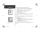
As you become more familiar with the cursor, you’ll see that the map display actively scrolls or
‘pans’, letting you explore areas around the world and create waypoints and routes. Wherever you
move the cursor, you’ll always be just one QUIT keystroke away from returning the map to your
present position.
Now that you’ve seen how the Map Page can be used to monitor your present location, let’s take a
minute to learn how to mark and store your present position as a “waypoint”. Since you’re in simulator
mode, the present position displayed is the last position calculated by the receiver, which should be
the spot where you’ve initialized the unit. This also gives you an opportunity to see how the GPSMAP
178C Sounder’s keypad and ENTER/MARK key are used for data entry and changing the waypoint
name and symbol.
Current position
Map Scale
Map Cursor
Cursor
Coordinates
Distance/
Bearing
GPSMAP178CManual.indd 9 3/19/2004, 3:09:57 PM