


27
Map Page Options
Reference
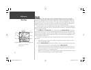
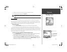
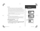
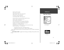
General Tab
Detail— Most, More, Normal, Less, Least: controls how much map detail displays. Those
features which have a specifi ed scale or turned “Off” are unaffected by this setting.
Orientation— North Up— fi xes the top of the map display to a north heading; Track Up
Below— fi xes the top of the map display to the current track heading and centers your position
on the lower portion of the screen. Set to ‘Off; for constant Track Up. The numeric value is the
range the unit switches to North Up when zooming out.; Course Up— fi xes the map so the
direction of navigation is always “up” and turns the navigation leg line vertical on the screen.
AutoZoom— On/Off: when “On” the map automatically adjusts the map scale to a lower scale
as you approach you destination point.
Color Mode — For Sun, For Dark: “For Sun” mode uses a bright color scheme for daylight
viewing. “For Dark” mode uses a dark color scheme for night viewing.
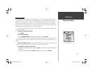
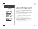
Source Tab
Basemap— On/Off: turns the built in base map on or off.
Data Card Maps— On/Off: turns all optional BlueChart/MapSource data loaded on the data
card on or off. The ‘Data Card Maps’ option box shows a list of the optional BlueChart/
MapSource data loaded on the data card. Each area is described by name and may be dese-
lected if you do not wish to display the data on the Map Page.
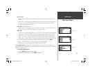
To display the Map Information Page:
1. Highlight the ‘Data Card Maps’ option box and press ENTER.
2. Use the ARROW KEYPAD to scroll through the list of maps.
3. To select/deselect a map family, highlight the check box to the left of the name and press ENTER
to select/deselect the map. The map is selected and is displayed on the Map Page when an “9”
appears in the box adjacent to that map. You may also press MENU and choose to ‘Show All’ or
‘Show None’ and press ENTER. (continued)
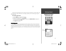
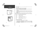
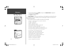
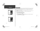
Source Tab
‘Data Card
Maps’ Map
Information
Page
General Tab
GPSMAP178CManual.indd 27 3/19/2004, 3:10:08 PM