


70
Reference
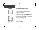
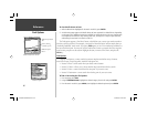
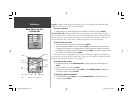
Main Menu: GPS Tab
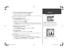
The status fi eld shows one of the following conditions:
• Looking For Satellites – the receiver is looking for any satellites.
• AutoLocate – the receiver is looking for any satellite whose almanac has been collected. This
process can take up to fi ve minutes.
• Acquiring Satellites – the receiver is looking for and collecting data from satellites visible at its last
known or initialized position, but has not collected enough data to calculate a fi x.
• 2D – at least three satellites with good geometry have been acquired and a 2 dimensional position
fi x (latitude and longitude) is being calculated. ‘2D Differential’ appears when you are receiving
DGPS corrections in 2D mode and a ‘D’ shows on the strength bar of satellites being corrected.
• 3D – at least four satellites with good geometry have been acquired and your position is now being
calculated in latitude, longitude and elevation. ‘3D Differential’ appears when you are receiving
DGPS corrections in 3D mode and a ‘D’ shows on the strength bar of satellites being corrected.
• Poor GPS Coverage – the receiver is no longer tracking enough satellites for a 2D or 3D fi x.
• Receiver Not Usable – the receiver is unusable, possibly due to interference or abnormal satellite
conditions. Turn the unit off and back on to reset.
• Simulating – the receiver is in simulator mode.
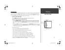
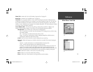
The Differential Receiver status shows one of the following:
• Off – No optional beacon receiver attached or enabled in the Comm menu or WAAS Off
• Searching For WAAS – WAAS is enabled and receiver is searching for WAAS signal
• Using WAAS – WAAS capability enabled and unit receiving WAAS corrections
• No Beacon Signal – DGPS receiver attached, but not transmitting RTCM data to GPS
• Tuning Beacon – Receiver is tuning manual DGPS frequency
• Receiving Beacon – Unit is receiving DGPS corrections
• Scanning Beacon – DGPS receiver is scanning for available frequency
• Using DGPS – Indicates a Differential signal is being received (only displays when the Serial Data
Format is set to “Other DGPS” on the Comm Tab of the Main Menu).
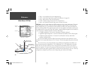
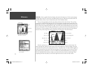
When the GPSMAP 178C is using a differential
correction signal (either WAAS or DGPS), a “D”
is displayed at the bottom of the signal strength
indicator bars for the satellites that are corrected.
GPSMAP178CManual.indd 70 3/19/2004, 3:10:38 PM