


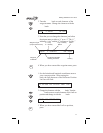

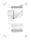

Note
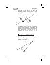
The GPS antenna must be able to “see”
each satellite it is tracking. If a satellite is
“shaded” by the wing or fuselage during a
turn, it may temporarily lose track of that
satellite. If this happens, or if the geometry
of the satellites available is poor, the unit
may temporarily calculate a “2D Fix” and
Nav information will not be available. A
NAV INVALID FLAG will be generated and
all Nav information will be dashed.
Entering a
Destination
Waypoint
With a seed position and the current UTC time and
date set, the Apollo SL50/60 is ready to begin
navigating a trip. Prepare for trip navigation by
entering a destination waypoint.
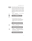
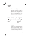
Using the Nearest Waypoint Function
1. Press the NRST key in the SL50 or press MSG
twice in the SL60. The GOTO Nearest Waypoint
function is displayed with the distance and
bearing from your present position to the
indicated waypoint. See page 41 in the Waypoint
section for a more complete description of using
the Nearest Waypoint function.
ARPT 1 SLE Brg 3520T 5.4nm
2. Turn the Large knob to view the different
waypoint types.
VOR 1 UBG Brg 3440T 26.6nm
3. Turn the Small knob to view the 20 nearest
waypoints.
VOR 2 CVO Brg 1890P 27.5nm
14
Getting Started the First Time